


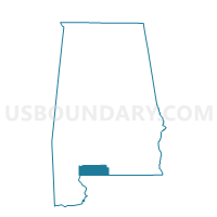
Rachel Patterson Elementary School, Escambia County, Alabama
About
Outline

Summary
| Unique Area Identifier | 521752 |
| Name | Rachel Patterson Elementary School |
| County | Escambia County |
| State | Alabama |
| Area (square miles) | 2.06 |
| Land Area (square miles) | 2.05 |
| Water Area (square miles) | 0.02 |
| % of Land Area | 99.22 |
| % of Water Area | 0.78 |
| Latitude of the Internal Point | 31.01042990 |
| Longtitude of the Internal Point | -87.50418310 |
Maps


Graphs
Select a template below for downloading or customizing gragh for Rachel Patterson Elementary School, Escambia County, Alabama


Neighbors
Neighoring Voting District (by Name) Neighboring Voting District on the Map
- 515-Voting District, Escambia County, FL
- Atmore City Hall, Escambia County, AL
- Atmore Public Library, Escambia County, AL
- Atmore-County Road Dept, Escambia County, AL
- Nokomis Vol Fire Dept, Escambia County, AL
Top 10 Neighboring County Subdivision (by Population) Neighboring County Subdivision on the Map
Top 10 Neighboring Place (by Population) Neighboring Place on the Map
Top 10 Neighboring Unified School District (by Population) Neighboring Unified School District on the Map
Top 10 Neighboring State Legislative District Lower Chamber (by Population) Neighboring State Legislative District Lower Chamber on the Map
Top 10 Neighboring State Legislative District Upper Chamber (by Population) Neighboring State Legislative District Upper Chamber on the Map
Top 10 Neighboring 111th Congressional District (by Population) Neighboring 111th Congressional District on the Map
Top 10 Neighboring Census Tract (by Population) Neighboring Census Tract on the Map
- Census Tract 9705, Escambia County, AL (4,819)
- Census Tract 38, Escambia County, FL (4,366)
- Census Tract 9707, Escambia County, AL (3,518)